
WOMBATS IN SOUTH AUSTRALIA
Species’ distribution maps can provide a lot of valuable information on the population dynamics of a species, but they can also be misleading if you just look at the big picture, and don’t look at the finer detail of the natural and anthropogenic factors behind the distribution. You also need to understand the history of how these factors may have changed over time. The distribution of southern hairy-nosed wombats on the Eyre Peninsula and West Coast regions is a perfect example of this.
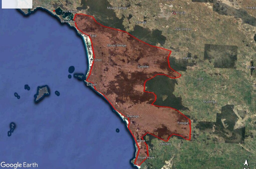
The map above shows the location of the main population group on Eyre Peninsula. In essence, it is located on the west coast of the peninsula between Venus Bay to the north and Mount Hope to the south. If you look closer, you will notice several distinguishing features that tell us a lot about southern hairy-nosed wombats. Firstly, the predominant land-use where wombats can be found is grazing land, and the rest of the peninsula (to the south-east; the bright green colour on the map) from where they are absent is predominantly cropping. You can also see that wombats are almost entirely absent from the darker olive-green coloured areas, which are conservation parks containing woodlands with dense scrubby understory. This tells us that southern hairy-nosed wombats favour open grassland, and that land clearance for grazing agriculture can actually favour the species, and result in an increase in population density (it is a little more complex than that, but in general it is an accurate summation); whereas land-clearance for cropping has the opposite effect.
You can see this more clearly in the map below, which shows the region between the Eyre Peninsula population to the south, the Gawler Ranges population to the north-east, and the Nullarbor population to the north-west.

The land-use in this region is predominantly cropping agriculture, and wombats are almost entirely absent as a result of control actions. However, it is important to note that, at the time of European colonisation, this region – and much of the Eyre Peninsula – was covered in woodlands, and the population density of wombats would have been quite low as a result.
The eastern edge of the main Nullarbor wombat population is near Penong, and the area around Penong /Nundroo / Bookabie is mainly mixed cropping and grazing, which sets up huge conflicts between farmers and wombats, as the wombats will occupy the land when it is used for grazing, but the farmers need to remove them when they want to grow crops.
But it is also important to note that this area was also once heavily wooded, and wombat numbers would have been lower then than they are now. We can still see this effect today in the Satellite map below (Figure 4) .

There are a large number of wombat warrens in the paddock which has been cut out of the scrub, but virtually none in the surrounding woodlands (The ground around this area has been carefully explored on foot to confirm this is the case). So, in effect, land-clearance has created a ‘wombat abundance’ problem for farmers that need to be resolved in order to be able to use the land that has been cleared.
The map below (Figure 3) is extremely interesting, as it shows another area where anthropogenic land-clearance has created habitat favourable for wombats.

The ‘Lockes Claypans’ (inside the red “ellipse”) are a series of ephemeral lakes (water only there somesimes) located in dense scrubby woodlands on sand-dunes to the south-west of the Gawler Ranges, separating the Gawler Ranges and Eyre Peninsula populations.
The land surrounding the lakes was completely unsuitable for wombats until it was cleared for grazing, and although there now is quite a sizable population of wombats in the area, they were completely absent in the 1970s. Our scientist who did this work strongly suspects they were never there. The scrubland surrounding the lakes is just too dense to walk through, even for a wombat. So how did they get there?
A possible hypothesis is that they arrived in the area by walking along the roads which have been cut through the thick scrub. Several road-kill wombats can be seen along these roads in areas far removed from any warrens, and there a number of burrows dug into the road shoulders, so they are definitely moving along the roads. It’s quite likely that as the population density of wombats on places like Hiltaba Station increased following the control of rabbits, the wombats needed to expand into new territory, and they explored along the roads until they found the newly cleared grazing lands around the lakes! This reasonable hypothesis needs to be tested.
In the next section you will see a map showing a number of historical points in the distribution and abundance of southern hairy-nosed wombats, before details about Northern hairy-nosed wombats are provided.